

NEW ROCHELLE, NY — The National Weather Service has issued a Tropical Storm Warning for the New York Metro Area including the Sound Shore of Westchester County. The next local statement will be issued by the National Weather Service in New York around 11 AM EDT, or sooner if conditions
warrant.
- CURRENT WATCHES AND WARNINGS:
- A Tropical Storm Warning is in effect.
- STORM INFORMATION:
- About 100 miles south of New York City NY or about 170 miles
southwest of Montauk Point NY
- 39.4N 74.3W
- Storm Intensity 50 mph
- Movement Northeast or 45 degrees at 31 mph
SITUATION OVERVIEW
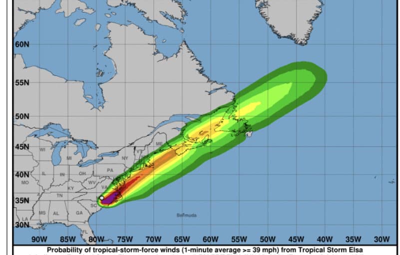
Tropical Storm Elsa will track northeast over Long Island
and southeast New England this morning.
The main threats from Elsa are heavy rain capable of producing flash
flooding, tropical storm force winds along the south shore and east
end of Long Island and across southeast Connecticut, and associated
marine and coastal hazards, including very rough seas and dangerous
rip currents.
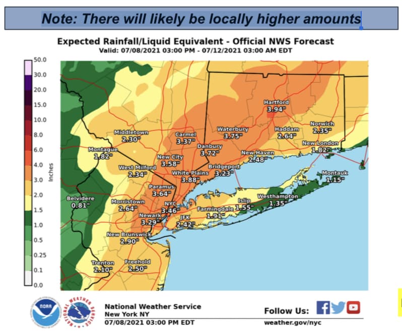
A widespread rainfall of 2 to 4 inches with locally higher amounts is
forecast through this afternoon. The highest amounts are forecast to
be across western Long Island, northeastern New Jersey, the Lower
Hudson Valley, and much of southern Connecticut. This will present a
likelihood for scattered areas of flash flooding, particularly for
areas that saw heavy rain over the last couple of days.
Dangerous marine conditions are likely on the ocean waters south of
Long Island, as well as on Long Island Sound, and the south shore and
eastern bays of Long Island. Tropical storm force winds will be most
likely in those areas, near the south shores and east end of Long
Island and southeast Connecticut, and in some higher elevations away
from the coastline. Dangerous rip currents and high surf are expected
along the ocean beaches of Long Island through Friday.
POTENTIAL IMPACTS
- FLOODING RAIN:
Prepare for life-threatening rainfall flooding having possible
extensive impacts across Southeast New York, Northeast New Jersey,
and Southern Connecticut.
Potential impacts include:
- Major rainfall flooding may prompt many evacuations and rescues.
- Rivers and streams may rapidly overflow their banks in multiple
places. Small streams, creeks, canals, and ditches may become
dangerous rivers. Flood control systems and barriers may become
stressed.
- In hilly terrain, destructive runoff may run quickly down
valleys, and increase susceptibility to rockslides and
mudslides.
- Flood waters can enter many structures within multiple
communities, some structures becoming uninhabitable or washed
away. Many places where flood waters may cover escape routes.
Streets and parking lots become rivers of moving water with
underpasses submerged. Driving conditions become dangerous.
Many road and bridge closures with some weakened or washed out.
- WIND:
Prepare for hazardous wind having possible limited impacts across cross
southern and eastern portions of Long Island and southeastern
Connecticut.
Potential impacts in this area include:
- Damage to porches, awnings, carports, sheds, and unanchored
mobile homes. Unsecured lightweight objects blown about.
- Many large tree limbs broken off. A few trees snapped or
uprooted, but with greater numbers in places where trees are
shallow rooted. Some fences and roadway signs blown over.
- A few roads impassable from debris, particularly within urban
or heavily wooded places. Hazardous driving conditions on
bridges and other elevated roadways.
- Scattered power and communications outages.
Elsewhere across Southeast New York, Northeast New Jersey, and
Southern Connecticut, little to no impact is anticipated.
- TORNADOES:
Tornadoes may be possible, with limited impacts across Long Island and
southeastern Connecticut.
Potential impacts include:
- The occurrence of isolated tornadoes can hinder the execution
of emergency plans during tropical events.
- A few places may experience tornado damage, along with power
and communications disruptions.
- Locations could realize roofs peeled off buildings, chimneys
toppled, mobile homes pushed off foundations or overturned,
large tree tops and branches snapped off, shallow rooted trees
knocked over, moving vehicles blown off roads, and small boats
pulled from moorings.
Elsewhere across Southeast New York, Northeast New Jersey, and
Southern Connecticut, little to no impact is anticipated.
- SURGE:
Little to no impacts are anticipated at this time, with a
reasonable worst case scenario of up to 1 foot above ground level
across vulnerable locales along Lower NY harbor, Jamaica Bay, Great
South Bay, coastal Westchester and coastal Connecticut.
- OTHER COASTAL HAZARDS:
Dangerous rip currents are expected at Atlantic ocean beaches
through Friday, as well as high surf and beach erosion. Minor
damage to dune structures is possible.
PRECAUTIONARY/PREPAREDNESS ACTIONS
- OTHER PREPAREDNESS INFORMATION:
Always heed the advice of local officials and comply with any
orders that are issued. Remember that during the storm 9 1 1
Emergency Services may not be able to immediately respond if
conditions are unsafe.
Keep cell phones well charged.
Rapidly rising flood waters are deadly. Never drive through a flooded
roadway. Remember, Turn Around Dont Drown!
There is threat of tornadoes with this storm. Have multiple ways to
receive Tornado Warnings. Be ready to shelter quickly in case a
tornado is spotted or a Tornado Warning is issued. If a Tornado
Warning is issued for your area, be ready to shelter
quickly, preferably away from windows and in an interior room not
prone to flooding. If driving, scan the roadside for quick shelter
options.
Closely monitor http://weather.gov, NOAA Weather radio or local news
outlets for official storm information. Be ready to adapt to possible
changes to the forecast. Ensure you have multiple ways to receive
weather warnings.
- ADDITIONAL SOURCES OF INFORMATION:
- For information on appropriate preparations see http://ready.gov
- For information on creating an emergency plan see
http://getagameplan.org
- For additional disaster preparedness information see
http://redcross.org
NEXT UPDATE
The next local statement will be issued by the National Weather Service in New York NY around 11 AM EDT, or sooner if conditions
warrant.